Bonnet Rouge
Description
-
From the parking lot, walk up to the village of l'Epine. At the war memorial, turn left and at the end of the village follow the tarred road towards Les Struis and La Villette.
- At the crossroads, turn left. 300 m further on, before a bridge, follow a path that goes right to the Struis.
- Cross the hamlet on your way up and continue on a track on the opposite side. At the fork, take the right track which leads to a field. Walk along it to the left and then follow a path that will lead you to the pass, Col des Trousses (1266 m).
- At the pass, follow the 2nd track on the right up to the pass Col du Pré ("Col de Champlat", 1501 m).
- From there, a return trip takes you to the top of Bonnet Rouge (1645 m). To do this, leave the track and go straight on to a small pasture. 40 m further, turn right and cross a small wood. A walk on the mountainside goes around this summit to the left and leads you to Champlat. Continue along the ridge to the right and enjoy a beautiful 360 ° view. Return to Col du Pré following the same track back and take to the left direction of l’Épine. The track narrows and becomes a path when arriving at a small pass. After a long descent, walk along a ruined sheepfold and continue straight until a track crosses.
- Turn right to reach the hamlet Mathieu, and take the road to the left for reaching L'Épine.
- Departure : Parking lot in front of the hostel, l'Épine
- Arrival : Parking lot in front of the hostel, l'Épine
- Towns crossed : Épine
Forecast
Altimetric profile
Recommandations
- Spend some time and visit the charming hilltop village of l’Epine. In September, a traditional fair takes place in the village: The pumpkin festival.
Information desks

Transport
Access and parking
Parking :
2 points of interest

 Pass
PassPass des Trousses
Located at an altitude of 1266 m, the pass des Trousses is a crossroad between 3 passes: the Col des Tourettes, the Col d'Arron and the Bonnet Rouge.
 Summit
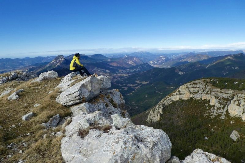
Bonnet Rouge
Highest point of the cliff - 1645 meters high - the Bonnet Rouge is one of the main ridge’s summits with the Serre de la Bouisse liking Serre to l’Epine. The quite steep path allowing you to get there is worth the effort because the view is very splendid. From up there, a 360° panoramic view opens on the Dévoluy, the Écrins, the Préalpes hilly area, Ubaye valley and Ventoux Mount.
More information
Report a problem or an error
If you have found an error on this page or if you have noticed any problems during your hike, please report them to us here: