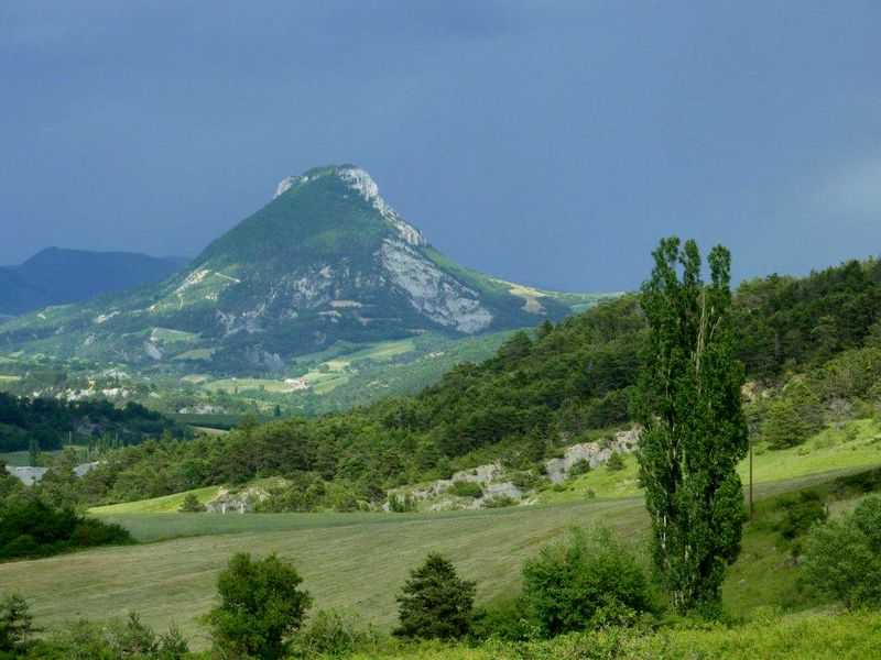
Montagne du Risou
Moydans Medium
Montagne du Risou
2h
2,6km
+382m
-382m
Return trip
Embed this item to access it offline
Description
- In Palluel, the path starts to the right of a small valley, in the undergrowth, then climbs steeper and winds through a forest of Scots pines. The climb becomes more and more rocky and straight and leads to a first rocky plateau.
- The trail continues with a short passage requiring a stairway climb to quickly reach the plateau. The biotope changes little by little, the pines give way to downy oaks and boxwood. Enjoy the landscape, it justifies alone all the efforts of the climb.
- Arrived at the Chapelle Saint-Jean, it is possible to go further by continuing on the ridge; enjoy the best panorama that this mythical summit offers. The same path brings you back to your starting point.
- Towns crossed : Moydans and Saint-André-de-Rosans
Forecast
Altimetric profile
Recommandations
- The climb to the ridge quickly becomes very steep.
- Good shoes are essential because the descent is slippery.
- There is a hole in the rock on the south side below the ridge. You may have the chance to observe it (be careful, just behind it, it is a vertical cliff).
Information desks

Transport
- Think about public transport and carpooling: https://zou.maregionsud.fr
Access and parking
From Serres (18 km), take the D 994 towards Rosans, then, at Col de Palluel, follow the D 425 for 250 m towards Saint André de Rosans. Parking: D 425 at Col de Palluel, Moydans
2 points of interest
 Panorama
Point of view
From the heights of the Risou Mountain, an exceptional panorama emerges over the entire Rosanais valley. The various surrounding villages such as Rosans, Moydans, Ribeyret and l'Épine as well as the surrounding mountains can be seen. Geology
The Risou mountain
Located in the Moydans area, the Risou Mountain is made up of a steep relief that makes it standout from the landscape. The rock wall at its top stands out as well as its visible ridge.
More information
Report a problem or an error
If you have found an error on this page or if you have noticed any problems during your hike, please report them to us here: