Saint-Genis Mountain circuit
Description
- From the parking lot, follow the path on your left. Step over the fence and reach « Le Pas de Jubéo ».
- Take a rocky path hiking up on your left to Sait-Genis Mountain side
- At the « sous le pas de l’Aup » signpost, you can do a roundtrip to the Roc de l’Esculier (1432 m): take the left path through broom flowers to reach the ridges.
- At the junction, follow « Colombier pass » on your right. Go on a track and after two hairpin bends, turn left towards Colombier pass (1151 meters).
- At Colombier pass, continue on your way and take the track heading straight to Lazer pass.
- At Lazer pass (1191 m), take a path on your left and reach the grazed ridge. Follow it until « Porte Sereine ».
- At « Porte-Sereine », take the path on your right and go down into a beeches woodland which transforms into a pine trees one. On your left, go down a path leading to a forest track until « Le Chastel » signpost.
- Follow the left track and at the « RF du château » signpost, take the path going down the slope towards the canyons and reach a junction a 100 meters further.
- Follow the right path leading to Jubéo’s parking lot. Cross over the Riou river by a small bridge and hike up again in a pine trees forest until Jubéo’s parking lot.
- Towns crossed : Savournon, Garde-Colombe, Ventavon, and Laragne-Montéglin
Forecast
Altimetric profile
Information desks

Place du village, 05700 Orpierre

Access and parking
From Laragne (22 km), take the departmental road D 1075 and the departmental road D 21 towards Savournon and then take the departmental road D 221 to reach Jubéo.
Parking :
5 points of interest
 Panorama
Outlook
When you reach the higher up part of the first big rise of the path, there is an overview on Laragnais valley and Saint-Genis town and Corrie.
 Summit
Located at 1432 meters high, Le Roc de l’Esculier is the highest point of Saint-Genis Mountain. From this place, a wonderful panoramic view allows you to discover Savournon valley and Saint-Genis Corrie. Many hilly areas like Chabre Mountain, Lure Mountain or Arambre mountain can be seen. Further, Dévoluy mountains and Ventoux mount can be seen too.
 Pass
PassColombier pass
Colombier pass located at 1160 meters high, splits up the two Aup mountain’s sides – Aup is another name for Saint-Genis Mountain –. From the pass, you can go to many villages like Lazer, Eyguians, Saint-Genis and Savournon.
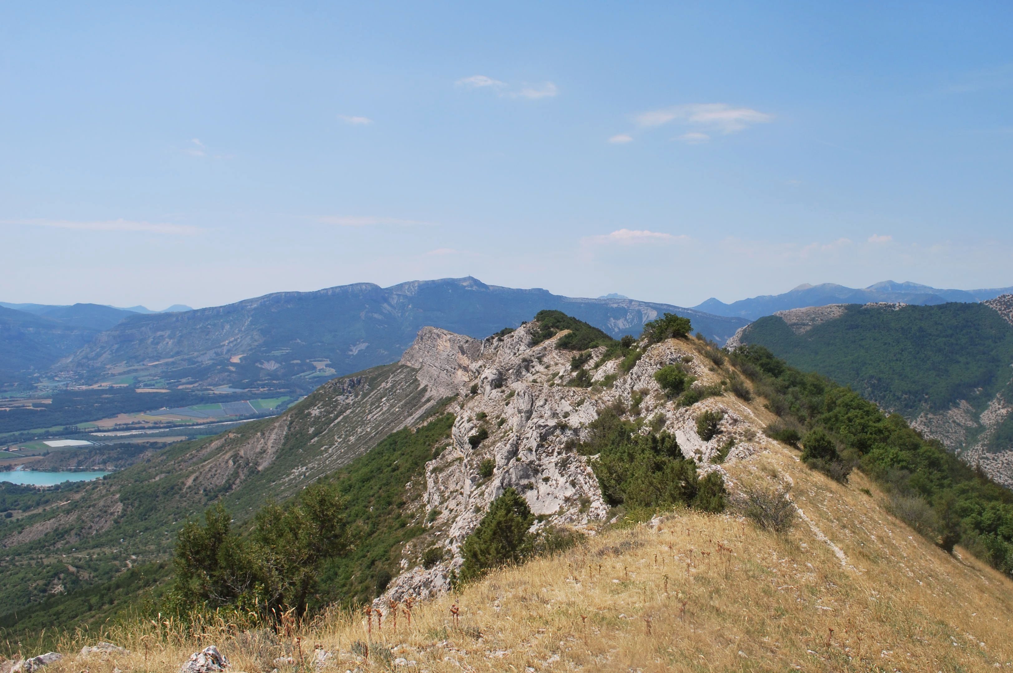
 Geology
Saint-Genis mountain’s ridge.
The ridge of the « Saint-Genis Mountain circuit »’s hiking is an unmissable passage. This place offers a beautiful panoramic view on Le Laragnais, Channe valley and the Serrois. Many hilly areas like Lure Mountain, Monges mountain, Dévoluy mountain, Arambre mountain and more can be seen.
 Lake and river
The Riou
The Riou takes its source at the bottom of the valley, digging beautiful gorges. It then comes to fill the Riou lake, very popular spot among tourists and locals during hot Summer days.
More information
Report a problem or an error
If you have found an error on this page or if you have noticed any problems during your hike, please report them to us here: